Disappearing Lake Tuz
- 16.12.2021
- Author:Dr. Fulya Aydın Kandemir
- (0) Comment
- 1203
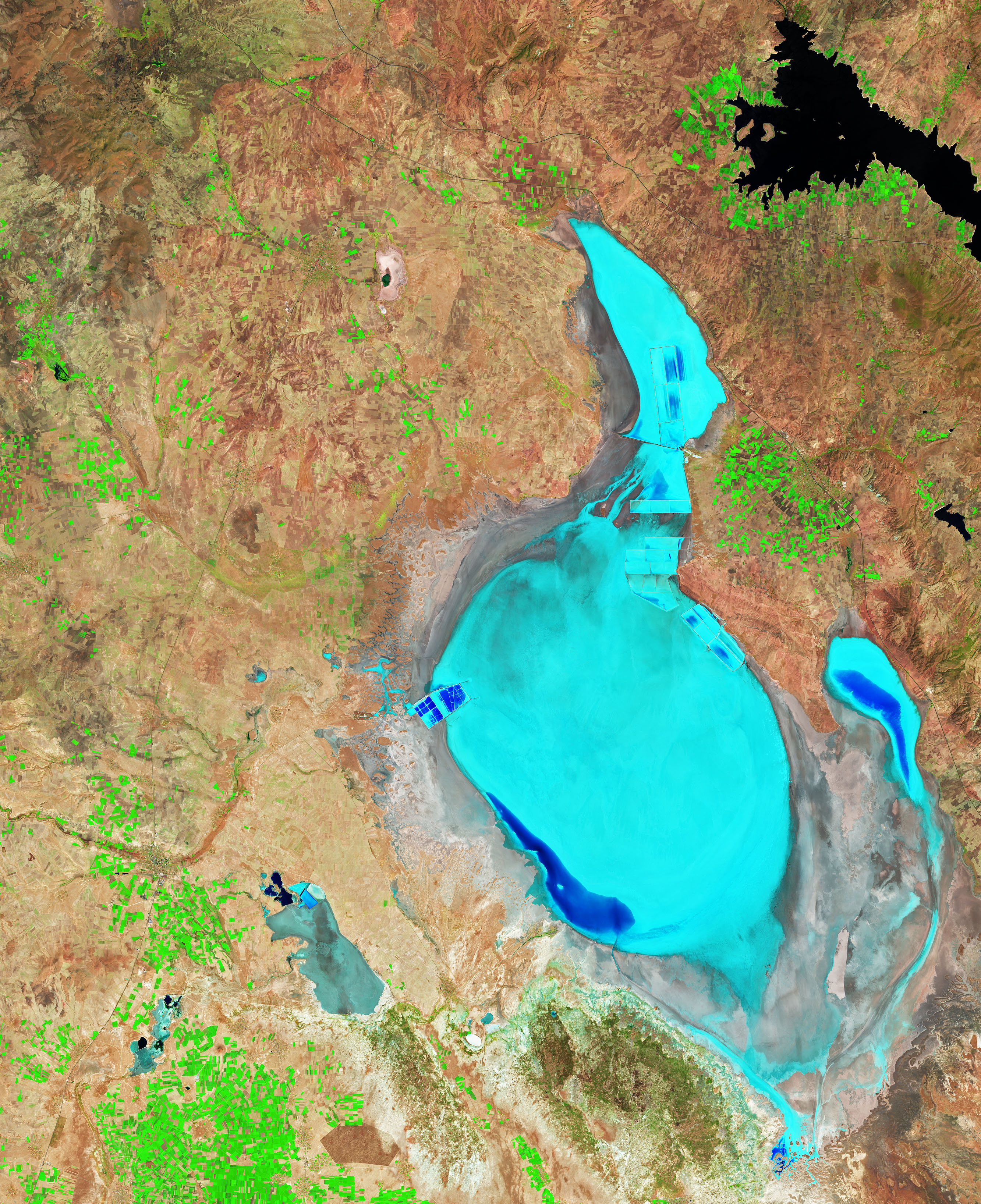
August 9, 2021JPEG
Lake Tuz was once the second-largest lake in Turkey. Flamingos flocked there to feed and nest. People visited to witness the lake’s seasonal color changes and to steep in the mineral rich water, mud, and salt.
Now, the lake rarely spans an area much larger than a puddle. In some summers it completely dries up. “Lake Tuz is unfortunately in danger of desiccation,” said Fulya Aydin-Kandemir, a scientist at the Hydropolitics Association of Turkey, and external lecturer at Akdeniz University.
Lake Tuz is a saline lake (Tuz is Turkish for “salt”) located on the Central Anatolia plateau, about 150 kilometers (90 miles) south-southeast of Ankara. It is fed by groundwater that originates in the Northern Taurus Mountains and passes through Konya Plain and Obruk Plateau bubbles up into Lake Tuz via springs. Other sources of water include two major streams, and rain that primarily falls in the springtime. The lake has no outlet.
Water here has become increasingly scarce. The Mediterranean Basin, which includes Turkey, has already seen more frequent and intense droughts, according to a report by the Mediterranean Experts on Climate and Environmental Change. In addition, the Mediterranean Basin is considered a climate change hotspot, having warmed more since the pre-industrial period compared to the global average (1.5°C/2.7°F compared to 1.1°C/2.0°F).
Aydin-Kandemir (previously at Ege University) and colleagues decided to examine how Lake Tuz has changed in recent decades, and to what extent the changes have been influenced by climatological conditions such as drought. To find out, they began by classifying lake’s various surface types—water, salt, and marsh—using false-color images acquired each August between 1985 and 2016 by Landsat satellites. Their findings were published in Regional Environmental Change.
The images used in the study were similar to the false-color image above, acquired on August 9, 2021, with the Operational Land Imager (OLI) on Landsat 8. Shortwave infrared, near-infrared, and red light (OLI bands 6-5-4) were used to distinguish the different surface types; in this view, water appears dark blue, salt is teal, and marshes are brown.
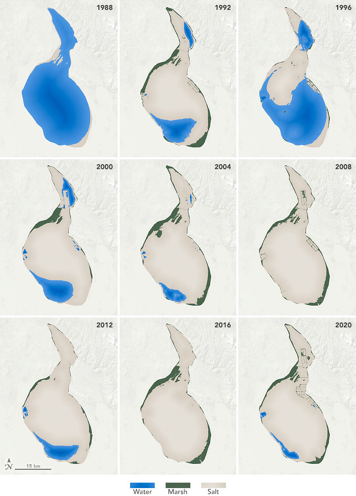
1988 - 2020
Next, the Landsat images were converted into maps showing how the spatial extent of water, salt, and marsh has changed. The maps above show the lake every few years; they are a subset of the annual maps published by the scientists in their paper.
The maps revealed two distinct periods. Prior to 2000, Lake Tuz generally contained enough water in August for the lake to be considered permanent. From 1985 through 2000, water-filled more than 20 percent of the lake (based on the current shoreline) in all years except 1992 and 1994. At its fullest, during the humid years of 1988 and 1996, water spanned 93 percent and 58 percent of the lake, respectively. Even during drought conditions in 1992, water still managed to cover 16 percent of the lakebed.
“The presence of permanent water in the southwestern and western parts of the lake was vital for breeding and feeding species such as flamingos because the bacteria they feed on were concentrated in this part where the salinity is lower,” Aydin-Kandemir said.
After the year 2000, there was a distinct shift. Between 2001 and 2016, water spanned less than 20 percent of the lake in every August (except 2015) as droughts became more frequent and intense. In 2008 and 2016, the lake completely dried up. Aydin-Kandemir’s current research shows that more recently, extraordinary meteorological drought has devastated Lake Tuz since 2019.
“In July 2021, the state was worse, and there was almost no water, which resulted in the mass death of baby flamingos that came to the lake this year,” Aydin-Kandemir said.
The patterns led the scientists to wonder why the lake had become more sensitive to drought after the year 2000. Before that time, Lake Tuz usually contained water even during periods of drought. But something changed.
Aydin-Kandemir noted that Lake Tuz’s decline coincided with the “excessive use of groundwater and surface-water resources feeding the lake.” For example, some streams were rerouted to irrigate agriculture, and some were dammed to meet the water needs of the surrounding provinces. And as surface water dwindled during intense drought, people turned to the groundwater that historically fed the springs.
“The future is quite uncertain for the lake,” Aydin-Kandemir said. With drought conditions expected to become more severe, people might continue to extract water at current levels. “The lake is not expected to reach the 1988-water area in the future,” she added.
NASA Earth Observatory images by Joshua Stevens, using Landsat data from the U.S. Geological Survey and data courtesy of Aydin, F., Erlat, E., & Türkeş, M. (2020). Story by Kathryn Hansen.

Once the second-largest lake in Turkey, it now rarely spans an area much larger than a puddle.
Image of the Day for December 16, 2021
- Instruments:
- Landsat 5 — TM
- Landsat 7 — ETM+
- Landsat 8 — OLI
References & Resources
- Aydin, F. et al. (2020) Impact of climate variability on the surface of Lake Tuz (Turkey), 1985–2016. Regional Environmental Change, 20 (68).
- France24 (2021, June 8) UN report says Mediterranean ‘climate change hotspot’ will see temps 20% higher than global average. Accessed December 15, 2021.
- Hürriyet Daily News (2012, August 30) Lake worth its salt for cosmetics. Accessed December 15, 2021.
- MedECC (2020) Climate and Environmental Change in the Mediterranean Basin–Current Situation and Risks for the Future. First Mediterranean Assessment Report. Accessed December 15, 2021.
- Phys.org (2019, October 10) Mediterranean basin badly hit by climate change: study. Accessed December 15, 2021.
Source :https://earthobservatory.nasa.gov/images/149211/disappearing-lake-tuz


Share Your Comments
Only members can comment, Click here to sign up for free right now